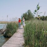
Between lake, reeds and visual art, this loop starting in Cheyres offers an escapade where nature and creativity are harmoniously intertwined.
From the very first steps, the path invites you to walk along the shores of Lake Neuchâtel, lined with reed beds and discreet observatories offering great views of the flora and fauna of the Grande Cariçaie.
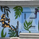
The highlight of the itinerary is the Cheyres pumping station, transformed into an artistic medium by the work ‘Les animaux de la Grande Cariçaie’ (‘The animals of the Grande Cariçaie’) by Ipi Création. This contemporary fresco, which is both playful and educational, illustrates the region's emblematic biodiversity with finesse. It is part of the ArtiChoke art trail, which adds creative touches to the Broye landscapes.
The trail then continues through meadows and undergrowth, bringing the route to a close in a peaceful atmosphere conducive to contemplation. An original and accessible way to rediscover the natural and cultural riches of Cheyres and the surrounding area.
Start: Car park below Cheyres railway station
A diversion is currently in place at the pond, which cannot be crossed but must be bypassed.


Properties of the itinerarie
Difficulty: Very easy
Duration: 01:13
Distance: 4 km
Ascent/Descent: +26m / -26m
Altitude min./max.: 430m / 436m
Itinerary type
- Loop itinerary
- Scenic hike
- Family hike
- Along the water