
The beaver trail between Cressier and Courtepin offers relaxation for body and mind on a 5km route!
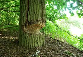
This hiking route connects Courtepin and Cressier (FR) train stations by following the Bibera (beaver) river. This peaceful stream rises in Courtaman and disappears into the Broye in Sugiez. It is outside the sounds of civilization that walkers and families can enjoy the charms and scents of nature. A few years ago, a successful revitalization project allowed the beavers to recolonize these areas. By being discreet, some may have the chance to observe one of these charming aquatic rodents with prominent teeth and flattened tails. If this is not the case, the vision of the trees sharpened in pencil point, irrefutable witnesses of its presence, will be a nice consolation prize.
The path is also marked by didactic boards providing information on the surrounding villages, as well as on the works and installations carried out in this place during the last decade.
Info: this path can also be done by bike, ideal for families!
Accessible by public transport: yes (Transports publics fribourgeois, line S20/21)
Accessible by car: yes, parking at Courtepin or Cressier station and return by train
Properties of the itinerarie
Type of activity: Family
Difficulty: Easy
Duration: 01:30
Distance: 5 km
Ascent/Descent: +21m / -58m
Altitude min./max.: 532m / 579m
Itinerary type
- Family hike
- Educational hike